THE ROADS OF CHIDDINGSTONE
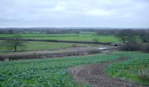
The maps below show the old roads c.1740, and the modern roads today. Of course, back in 1740 roads were differnt since they were designed for horses and people not cars. Seas of mud in the winter and rutted and cracked in the summer they were not as easy to travel on as now - but the network was much better. Hard to decide which was more convenient
The roads around Chiddingstone have changed alot in the last two hundred years. The biggest changes are the straightening of the roads around Vexour bridge (c1840), the diversion of the High Street when the Castle was remodeled in 1850 and the abandonment of the old Coach Road to Penshurst that went past Watstock (c 1890). The two maps below compare the layouts of the roads in 1750 and 1980. The railway (black line to the north) was built in 1840. The main farms are shown. Geers no longer exists and Somerden which in Jutish times (800AD) was important enough to give its name to the whole area (still referred to as the Somerden Hundred) is no longer connected to a major road.
|
|